
RangeFinder
Version:41
Published:2026-10-18
Introduction
RangeFinder is a precision distance-measurement Android app that turns your phone into a practical measuring tool for outdoor and indoor tasks. It combines GPS, camera-assisted targeting, and manual input to deliver quick distance estimates, area calculations, and annotated measurements suitable for hobbyists, professionals, and DIY projects.
What the app does
The core purpose of RangeFinder is to provide reliable, fast measurements without extra hardware. Using a mix of sensors, on-screen overlays, and mapping data, the app handles single-line distances, two-point elevation, and area computations. Measurements can be exported, saved to projects, or shared as annotated images for reporting or communication.
Main features at a glance
- GPS-based distance: Get straight-line estimates between two coordinates with optional route tracking.
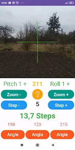
- Camera targeting: Aim at objects using an on-screen reticle to refine distance estimates where GPS is limited.
- Area and perimeter tools: Tap multiple points on a map or live view to calculate areas for land surveys or layout planning.
- Unit options: Switch between meters, feet, yards, and custom units for international use.
- Export & share: Save results to CSV, KML, or annotated image for easy documentation.
How measurements work
RangeFinder blends sensor fusion with manual input. GPS provides a reliable baseline for outdoor work, while camera-based measurements use device orientation and known height settings to derive distance through trigonometry. For precise indoor tasks, the app allows manual point entry and calibration against a known reference to improve accuracy.
Navigation and project workflow
The workflow is designed to fit fieldwork. Create a new project, add measurement points, and label each entry. Map layers help visualize locations and current position. Projects can be stored locally or backed up to cloud storage. Small teams benefit from exporting files that integrate into GIS or CAD systems.
Interface and usability
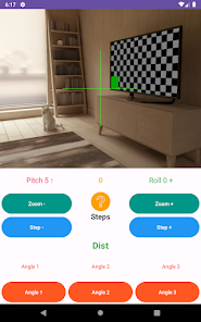
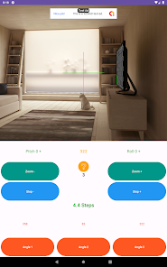
RangeFinder presents a clean, functional interface focused on quick access to tools. Large buttons and clear icons reduce errors when working outdoors. The camera view overlays distance readouts and angle indicators. Settings let users tune smoothing, GPS sampling rate, and default units to match the operation at hand.
Performance and accuracy considerations
Accuracy depends on device hardware and environmental conditions. Under clear sky, GPS delivers dependable horizontal distances; however, urban canyons and dense foliage can degrade results. Camera-assisted mode improves line-of-sight estimates but requires correct height and angle inputs for best performance. The app includes a calibration routine to minimize systematic error on particular devices.
Customization and advanced tools
Power users will appreciate configurable measurement modes and import options. RangeFinder supports custom reference heights, offset corrections, and a grid snapping feature for map-based point placement. Advanced export formats let surveyors bring data into professional workflows without reformatting.
Tips for new users
- Start with a short test run to learn how GPS behaves in your area.
- Use camera mode only when you have a clear line of sight and a steady hand or tripod.
- Calibrate the app against a measured distance to reduce bias on unfamiliar devices.
- Save frequently and name projects clearly to avoid confusion when working in multiple locations.
Why people choose this app
Users pick RangeFinder for its balance of functionality and accessibility. It replaces single-purpose tools for many everyday tasks, from landscaping planning to quick site checks. The export options and project handling make transitioning from an ad-hoc measurement to formal documentation straightforward.
Getting started
Install from the Play Store, grant necessary permissions for location and camera, then run the setup wizard. Set your preferred units and perform a basic calibration. With those steps complete, you can begin capturing points, creating areas, and sharing results within minutes.
For anyone needing a compact measurement toolkit on Android, RangeFinder offers a practical mixture of sensors, mapping, and export capabilities that support both casual and professional workflows.
Show More
Information
Screenshots
Latest Update








Hot Tags
Latest News
-
![Revealing the Launch Playlists and Cross-Progression for COD Warzone Mobile News]()
-
![March 2024 Free Redemption Codes for Honkai: Star Rail News]()
-
PUBG Mobile Teams Up with Bentley Motors: Luxury Cars, Exclusive Collectibles, and Beyond 2024-04-18
![PUBG Mobile Teams Up with Bentley Motors: Luxury Cars, Exclusive Collectibles, and Beyond News]()
-
![Monster Never Cry is now accessible on both Android and iOS mobile devices. News]()
-
V2.2 of the Farlight 84 update introduces an overhauled Season structure, fresh in-game currency, an 2024-04-16
![V2.2 of the Farlight 84 update introduces an overhauled Season structure, fresh in-game currency, an News]()
-
![Arrival of Genshin Impact 4.6 Update: 'Embers of Two Realms, Twilight of Crimson' News]()
-
April 2024 Clash of Clans Update: Unveiling a Fresh Companion, Enhanced Levels, Chat Tagging, and Be 2024-04-16
![April 2024 Clash of Clans Update: Unveiling a Fresh Companion, Enhanced Levels, Chat Tagging, and Be News]()